Planning is Important: The Urban Waterfront District


A VISION FOR UNION PIER
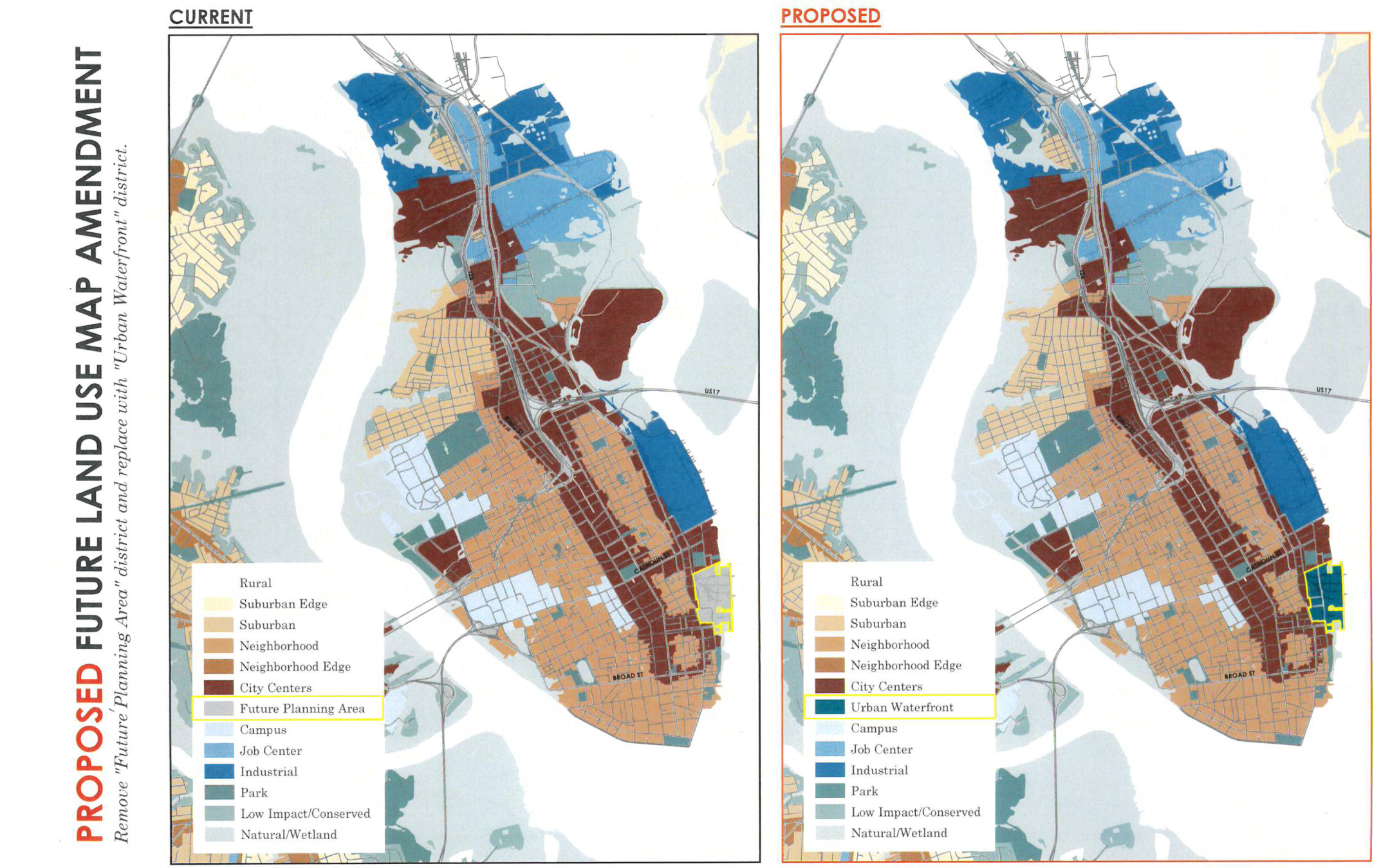
On April 8, 2025, Charleston City Council adopted an ordinance to amend the Charleston City Plan to include an Urban Waterfront District on the Future Land Use map. This comprehensive plan language reflects our priorities as we continue to advocate for development on Union Pier that reflects historic Charleston’s development patterns centered on an accessible and vibrant public realm.
Let's break down what this amendment to the Charleston City Plan actually means for the future of Union Pier — and why we support it.
What is a comprehensive plan?
Any municipality regulating land use in South Carolina (meaning, every city) is required to have a comprehensive plan as outlined in state law (1994 State Comprehensive Planning Act, SC Code Title 6, Chapter 19). The comprehensive plan, updated every five years and rewritten every ten years, is intended to serve as a guide for land use decision-making, zoning, and growth. The City of Charleston adopted its most recent comprehensive plan in October 2021. It is called the Charleston City Plan.
There are nine elements in every comprehensive plan. For the purposes of this post, we will focus on the Land Use element, which includes Future Land Use maps intended to guide land use decisions for the next ten years.
Within the Future Land Use maps, there are planning areas or districts, ranging from rural to industrial (see Table 1). Note the "Future Planning Area" designation that was assigned to the Union Pier site in the 2021 Charleston City Plan as a placeholder. More on that below.

.png)
How is the Future Land Use map updated?
When a change, or amendment, is proposed to the comprehensive plan, it must go through a multi-step public process. First, the amendment is reviewed by the Planning Commission. Then, it must pass three readings at City Council to be formally adopted.
The proposal to change the "Future Planning Area" to the "Urban Waterfront" district went before the City Planning Commission on February 19, 2025 and subsequently passed third reading at City Council on April 8, 2025. Each meeting provided an opportunity for public comment.
Why does HCF support the Urban Waterfront amendment to the Future Land Use map?
The language in the Urban Waterfront amendment establishes a visionary framework for Union Pier.
The roughly 70-acre site represents the largest redevelopment opportunity on Charleston's peninsula in decades. Currently owned by the South Carolina Ports Authority, Union Pier is poised to be developed by local businessman Ben Navarro, with assistance provided from the recently approved Union Pier Tax Increment Financing (TIF) district.
In 2021, when the City of Charleston was adopting its comprehensive plan, the future of Union Pier was uncertain. The Ports Authority had just abandoned plans to expand the cruise ship terminal, and discussions with potential developers were still preliminary.
Because of this uncertainty — and because no existing Future Land Use category reflected what the City and the public envisioned — the “Future Planning Area” placeholder designation was applied to the entire Union Pier site to allow time to develop a shared vision.
HCF has been a part of a collaborative team working with city planners to outline what we believe is essential for this site, including:
- Development that incorporates resiliency principles
- Continuous public access along the waterfront
- View corridors toward the water
- Compatibility with the city skyline as seen from land and water
- A mix of uses, including civic, retail, commercial, parks, greenspace and a variety of housing types
- Block patterns, street design and buildings that include varying heights and densities
- A properly scaled extension of the historic district
The comprehensive plan amendment captures these principles and represents the first step toward zoning changes and site plans.
HCF has been an integral part of this visioning process to ensure that the redevelopment of Union Pier does not result in uniform, unsustainable, vulnerable, boring, or poorly designed development.
APPROVED AMENDMENT LANGUAGE:
URBAN WATERFRONT FUTURE LAND USE DISTRICT: “These vibrant and inclusive mixed-use districts are located along portions of the Peninsula’s waterfront and areas designated as Neighborhood and City Centers. Development in these areas preserves Charleston’s rich cultural and maritime heritage and facilitates recreational, civic, and economic connections between urban areas and the waterfront. Building and site design prioritizes resilience, maintains continuous public access along the waterfront in coordination with perimeter protection, creates public access and street view corridors toward the water, and is compatible with the city’s skyline. There are a mix of uses, including a variety of housing types for residents of diverse incomes, civic, commercial, outdoor public gathering places, and opportunities for small and local businesses. The waterfront is activated with public parks and open spaces, as well as restaurants, events, and other public and commercial uses that engage and serve the Charleston community. Maritime recreational and transportation uses are encouraged on a scale consistent with landside uses, to replace prior cargo and cruise ship uses. Block patterns, street design and building scale and massing, which will include varying heights and densities, are compatible to the neighboring commercial and residential districts to create a properly scaled extension to the city.”
Do you want to see HCF's advocacy in action?
Watch the Planning Commission meeting from February 19, 2025 below, including comments from HCF President & CEO Winslow Hastie (timestamp: 1:21:37).